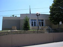
Elliott County
Kondado ang Elliott County (Prinanses: Comté d'Elliott, Kinatsila: Condado de Elliott, Prinanses: Comté dElliott) sa Tinipong Bansa.[1] Ang Elliott County nahimutang sa estado sa Kentucky, sa sidlakang bahin sa nasod, 500 km sa kasadpan sa ulohang dakbayan Washington, D.C. Adunay 7,852 ka molupyo.[2] Naglangkob kin og 609 ka kilometro kwadrado.
| Elliott County (Comté d'Elliott) | |
| Condado de Elliott, Comté dElliott | |
| Kondado | |
| Nasod | |
|---|---|
| Estado | Kentucky |
| Gitas-on | 250 m (820 ft) |
| Tiganos | 38°07′04″N 83°05′51″W / 38.11789°N 83.09762°W |
| Capital | Sandy Hook |
| Area | 609.20 km2 (235 sq mi) |
| Population | 7,852 gikan sa frwiki |
| Density | 13 / km2 (34 / sq mi) |
| Timezone | EST (UTC-5) |
| - summer (DST) | EDT (UTC-4) |
| GeoNames | 4291095 |
Ang yuta sa Elliott County kay patag.[saysay 1]
Mga lungsod sa Elliott County:
Sa mosunod nga mga natural nga mga bahin makita sa Elliott County:
- Mga suba:
- Anderson Branch (suba)
- Arabs Fork (suba)
- Bandy Branch (suba)
- Beech Branch (suba)
- Beech Branch (suba)
- Beech Branch (suba)
- Bentley Branch (suba)
- Benyan Creek (suba)
- Big Caney Creek (suba)
- Big Fork (suba)
- Big Gimlet Creek (suba)
- Bill Branch (suba)
- Bills Branch (suba)
- Birch Branch (suba)
- Birchfield Creek (suba)
- Blaine Trace (suba)
- Boggs Branch (suba)
- Booth Branch (suba)
- Bowling Branch (suba)
- Brier Branch (suba)
- Brier Fork (suba)
- Bruin Creek (suba)
- Brushy Creek (suba)
- Buck Fork (suba)
- Burton Branch (suba)
- Butcher Branch (suba)
- Caney Creek (suba)
- Clay Fork (suba)
- Clifty Creek (suba)
- Coffee Branch (suba)
- Collins Branch (suba)
- Dick Branch (suba)
- Doctors Branch (suba)
- Durham Fork (suba)
- Eldridge Branch (suba)
- Elkhorn Branch (suba)
- Fraley Branch (suba)
- Fraley Chapel Branch (suba)
- Fulton Fork (suba)
- Galion Branch (suba)
- Gilbert Fork (suba)
- Gillium Branch (suba)
- Green Branch (suba)
- Greens Branch (suba)
- Hamilton Creek (suba)
- Hog Camp Creek (suba)
- Hopkins Cave Branch (suba)
- Howards Creek (suba)
- Hurricane Creek (suba)
- Ira Ison Branch (suba)
- Ison Creek (suba)
- Jim Oliver Branch (suba)
- Johnson Creek (suba)
- Laurel Branch (suba)
- Laurel Creek (suba)
- Left Fork Hipple Fork Little Sandy River (suba)
- Left Fork Howards Creek (suba)
- Left Fork Rocky Branch (suba)
- Lick Fork (suba)
- Licklog Branch (suba)
- Little Brushy Creek (suba)
- Little Caney Creek (suba)
- Logan Branch (suba)
- Lower Clifty Creek (suba)
- Manbone Branch (suba)
- Mart Bear Branch (suba)
- Mart Whitt Fork (suba)
- Mason Branch (suba)
- Meadow Branch (suba)
- Middle Fork Little Sandy River (suba)
- Mud Lick (suba)
- Neal Howard Creek (suba)
- Newcombe Creek (suba)
- Nichols Fork (suba)
- North Ruin Creek (suba)
- Oliver Branch (suba)
- Open Fork (suba)
- Powder Mill Branch (suba)
- Pruetts Fork (suba)
- Right Fork Middle Fork Little Sandy River (suba)
- Right Fork Newcombe Creek (suba)
- Right Fork Rocky Branch (suba)
- Rockhouse Fork (suba)
- Rocky Branch (suba)
- Rocky Creek (suba)
- Rose Creek (suba)
- Salyers Branch (suba)
- Sandy Fork (suba)
- Sheepskin Branch (suba)
- Shop Branch (suba)
- South Ruin Creek (suba)
- Spruce Branch (suba)
- Stafford Creek (suba)
- Stinson Branch (suba)
- Tarkiln Creek (suba)
- Terry Branch (suba)
- Turkey Branch (suba)
- Upper Clifty Creek (suba)
- Wallow Hole Creek (suba)
- Wells Creek (suba)
- Whites Creek (suba)
- Wimberly Branch (suba)
- Mga tubud:
- Mga patag:
- Mga bungtod:
- Mga walog:
- Mga lasang:
- Kabukiran:
Ang klima umogon ug subtropikal.[4] Ang kasarangang giiniton 13 °C. Ang kinainitan nga bulan Hulyo, sa 22 °C, ug ang kinabugnawan Enero, sa 1 °C.[5] Ang kasarangang pag-ulan 1,552 milimetro matag tuig. Ang kinabasaan nga bulan Hulyo, sa 191 milimetro nga ulan, ug ang kinaugahan Nobiyembre, sa 73 milimetro.[6]
| ||||||||||||||||||||||||||||||||||||||||||||||||||||||||||||||||||||||||||||||||||||||||||||||||||||||||||||||||||||||||||||
Saysay
usbaAng mga gi basihan niini
usba- ↑ Elliott County sa Geonames.org (cc-by); post updated 2013-03-07; database download sa 2017-02-28
- ↑ (gikopiya gikan sa frwiki 2015-07-20)
- ↑ "Viewfinder Panoramas Digital elevation Model". 2015-06-21.
- ↑ Peel, M C; Finlayson, B L. "Updated world map of the Köppen-Geiger climate classification". Hydrology and Earth System Sciences. 11: 1633–1644. doi:10.5194/hess-11-1633-2007. Retrieved 30 Enero 2016.
{{cite journal}}: CS1 maint: unflagged free DOI (link) - ↑ 5.0 5.1 "NASA Earth Observations Data Set Index". NASA. Retrieved 30 Enero 2016.
- ↑ "NASA Earth Observations: Rainfall (1 month - TRMM)". NASA/Tropical Rainfall Monitoring Mission. Retrieved 30 Enero 2016.
Gikan sa gawas nga tinubdan
usba| Aduna'y mga payl ang Wikimedia Commons nga may kalabotan sa artikulong: Elliott County. |


