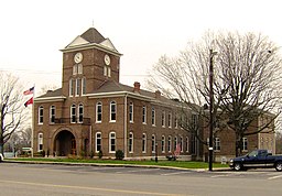
Meigs County (kondado sa Tinipong Bansa, Tennessee)
- Alang sa ubang mga dapit sa mao gihapon nga ngalan, tan-awa ang Meigs County.
Kondado ang Meigs County (Prinanses: Comté de Meigs, Kinatsila: Condado de Meigs) sa Tinipong Bansa.[1] Nahimutang ni sa estado sa Tennessee, sa sidlakang bahin sa nasod, 800 km sa habagatan-kasadpan sa Washington, D.C. Adunay 11,753 ka molupyo.[1] Naglangkob kin og 561 ka kilometro kwadrado. Meigs County mopakigbahin sa usa ka utlanan sa Roane County, ug Bradley County ang ulohan sa nasod.
| Meigs County (Comté de Meigs) | |
| Condado de Meigs | |
| Kondado | |
| Nasod | |
|---|---|
| Estado | Tennessee |
| Gitas-on | 255 m (837 ft) |
| Tiganos | 35°30′46″N 84°48′48″W / 35.51283°N 84.81339°W |
| Capital | Decatur |
| Area | 561.00 km2 (217 sq mi) |
| Population | 11,753 (2013-03-08) [1] |
| Density | 21 / km2 (54 / sq mi) |
| Timezone | EST (UTC-5) |
| - summer (DST) | EDT (UTC-4) |
| GeoNames | 4641148 |
Ang yuta sa Meigs County kay patag sa habagatang-sidlakan, apan sa amihang-kasadpan nga kini mao ang kabungtoran.[saysay 1]
Meigs County may sa mosunod nga mga subdibisyon:
Mga lungsod sa Meigs County:
Sa mosunod nga mga natural nga mga bahin makita sa Meigs County:
- Mga luuk:
- Mga suba:
- Agency Creek (suba)
- Allen Branch (suba)
- Allford Branch (suba)
- Anderson Spring Branch (suba)
- Beta Branch (suba)
- Big Sewee Creek (suba)
- Black Ankle Creek (suba)
- Chatton Spring Branch (suba)
- Clear Branch (suba)
- Coldwater Branch (suba)
- Coppinger Creek (suba)
- Dake Branch (suba)
- Davis Creek (suba)
- Decatur Branch (suba)
- Decatur Creek (suba)
- Dry Branch (suba)
- Dry Branch (suba)
- Dry Fork (suba)
- Dry Fork (suba)
- Evans Branch (suba)
- Good Hope Branch (suba)
- Goodfield Creek (suba)
- Gunstocker Creek (suba)
- Hale Hollow Creek (suba)
- Hardin Creek (suba)
- Hiwassee River (suba)
- Hurricane Creek (suba)
- Hutsell Branch (suba)
- Lagoon Branch (suba)
- Lewis Branch (suba)
- Lick Branch (suba)
- Lick Branch (suba)
- Lick Creek (suba)
- Marney Creek (suba)
- McCall Branch (suba)
- McKinley Branch (suba)
- Moore Branch (suba)
- Nance Branch (suba)
- Nebo Branch (suba)
- North Mouse Creek (suba)
- Pleasant Hill Branch (suba)
- Poe Branch (suba)
- Price Creek (suba)
- Rogers Creek (suba)
- Rowden Branch (suba)
- Russell Branch (suba)
- Sewee Creek (suba)
- Sivils Branch (suba)
- South Fork Little Sewee Creek (suba)
- Stewart Branch (suba)
- Sugar Creek (suba)
- Ten Mile Creek (suba)
- Wann Branch (suba)
- Watts Creek (suba)
- Mga tubud:
- Armstrong Spring (tubud)
- Ashley Spring (tubud)
- Big Spring (tubud)
- Carpenter Spring (tubud)
- Cave Spring (tubud)
- Crabtree Spring (tubud)
- Eaves Spring (tubud)
- Goforth Spring (tubud)
- Hawk Spring (tubud)
- Holloway Spring (tubud)
- Hornsby Spring (tubud)
- Keylon Springs (tubud)
- Kincaid Spring (tubud)
- Lockmiller Springs (tubud)
- Marler Spring (tubud)
- McCulley Spring (tubud)
- Perkinson Spring (tubud)
- Powell Spring (tubud)
- Powell Spring (tubud)
- Rockholt Spring (tubud)
- Russell Spring (tubud)
- Sensaboy Spring (tubud)
- Whitmore Spring (tubud)
- Mga lanaw:
- Kapuloan:
- Nga bato nga pormasyon:
- Mga bungtod:
- Able Ridge (tagaytay)
- Blalock Ridge (tagaytay)
- Brickell Ridge (tagaytay)
- Burdette Ridge (tagaytay)
- Correll Ridge (tagaytay)
- Cotton Port Ridge (tagaytay)
- Decatur Ridge (tagaytay)
- Ditney Ridge (tagaytay)
- Gilbert Ridge (tagaytay)
- Jenkins Ridge (tagaytay)
- Looney Ridge (tagaytay)
- McCulley Ridge (tagaytay)
- McMinn Ridge (tagaytay)
- Middle Ridge (tagaytay)
- Mount Carmel Ridge (tagaytay)
- No Pone Ridge (tagaytay)
- No Pone Ridge (tagaytay)
- Shiloh Ridge (tagaytay)
- Ten Mile Ridge (tagaytay)
- Ward Ridge (tagaytay)
- Mga lawis:
- Mga walog:
- Bird Hollow (walog)
- Brown Hollow (walog)
- Colbaugh Hollow (walog)
- Dodd Hollow (walog)
- Elder Hollow (walog)
- Fisher Hollow (walog)
- Goodfield Valley (walog)
- Hale Hollow (walog)
- Harmon Hollow (walog)
- Horner Hollow (walog)
- Hurricane Valley (walog)
- Lewis Valley (walog)
- Mount Zion Hollow (walog)
- Roberts Hollow (walog)
- Womac Hollow (walog)
- Woods Hollow (walog)
- Woolsey Hollow (walog)
- Kabukiran:
- Kagaangan:
Ang klima umogon ug subtropikal.[3] Ang kasarangang giiniton 14 °C. Ang kinainitan nga bulan Hulyo, sa 24 °C, ug ang kinabugnawan Enero, sa 2 °C.[4] Ang kasarangang pag-ulan 1,808 milimetro matag tuig. Ang kinabasaan nga bulan Disyembre, sa 224 milimetro nga ulan, ug ang kinaugahan Nobiyembre, sa 98 milimetro.[5]
| ||||||||||||||||||||||||||||||||||||||||||||||||||||||||||||||||||||||||||||||||||||||||||||||||||||||||||||||||||||||||||||
Saysay
usbaAng mga gi basihan niini
usba- ↑ 1.0 1.1 1.2 Meigs County sa Geonames.org (cc-by); post updated 2013-03-08; database download sa 2017-02-28
- ↑ "Viewfinder Panoramas Digital elevation Model". 2015-06-21.
- ↑ Peel, M C; Finlayson, B L. "Updated world map of the Köppen-Geiger climate classification". Hydrology and Earth System Sciences. 11: 1633–1644. doi:10.5194/hess-11-1633-2007. Retrieved 30 Enero 2016.
{{cite journal}}: CS1 maint: unflagged free DOI (link) - ↑ 4.0 4.1 "NASA Earth Observations Data Set Index". NASA. Retrieved 30 Enero 2016.
- ↑ "NASA Earth Observations: Rainfall (1 month - TRMM)". NASA/Tropical Rainfall Monitoring Mission. Retrieved 30 Enero 2016.
Gikan sa gawas nga tinubdan
usba| Aduna'y mga payl ang Wikimedia Commons nga may kalabotan sa artikulong: Meigs County. |


