Payl:Lake Abitibi 79.72W 48.75N.jpg

Gidak-on ning maong paunang tan-aw: 778 x 599 ka mga piksel. Uban pang mga resoluyon: 312 x 240 ka mga piksel | 623 x 480 ka mga piksel | 997 x 768 ka mga piksel | 1,280 x 986 ka mga piksel.
Tibuok resolusyon (1,280 × 986 pixels, size sa payl: 510 KB, MIME type: image/jpeg)
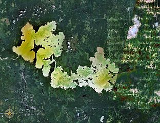
| Deskripsyon | Lake Abitibi, Ontario and Quebec, Canada. The border between the 2 provinces is visible as a vertical line between undeveloped terrain in Ontario and the rectangular agricultural patterns in Quebec (the right/east third of photo). |
| Gigikanan | NASA WorldWind |
| Tagsulat | NASA |
| This image is in the public domain because it is a screenshot from NASA’s globe software World Wind using a public domain layer, such as Blue Marble, MODIS, Landsat, SRTM, USGS or GLOBE.
|
 |
Kaagi sa payl
I-klik ang petsa/oras aron makit-an ang hulagway sa payl niadtong panahona.
| Petsa/Takna | Thumbnail | Mga dimensyon | Tiggamit | Komento | |
|---|---|---|---|---|---|
| kasamtangan | 17:23, 22 Enero 2007 | | 1,280 × 986 (510 KB) | P199 | {{Information |Description=Lake Abitibi, Ontario and Quebec, Canada |Source=NASA WorldWind |Date= |Author= |Permission= |other_versions= }} {{PD-WorldWind}} Category:Lakes of Ontario Category:Lakes of Québec |
Mga paggamit sa payl
Ang mosunod nga mga panid misumpay niining payl:
Global nga paggamit sa payl
Kining ubang wiki naggamit ning maong payl:
- Paggamit sa arz.wiki.x.io
- Paggamit sa bg.wiki.x.io
- Paggamit sa de.wiki.x.io
- Paggamit sa en.wiki.x.io
- Paggamit sa eo.wiki.x.io
- Paggamit sa es.wiki.x.io
- Paggamit sa et.wiki.x.io
- Paggamit sa fr.wiki.x.io
- Paggamit sa hr.wiki.x.io
- Paggamit sa it.wiki.x.io
- Paggamit sa lv.wiki.x.io
- Paggamit sa pl.wiki.x.io
- Paggamit sa pt.wiki.x.io
- Paggamit sa ru.wiki.x.io
- Paggamit sa sv.wiki.x.io
- Paggamit sa te.wiki.x.io
- Paggamit sa uk.wiki.x.io
- Paggamit sa www.wikidata.org
- Paggamit sa zh.wiki.x.io