Tibuok resolusyon (2,272 × 1,704 pixels, size sa payl: 1.91 MB, MIME type: image/jpeg)

Kining maong payl gikan sa Wikimedia Commons ug mahimong gigamit sa ubang proyekto. Ang deskripsyon niini didto gipakita sa ubos.

Mubong sugid:

Deskripsyon
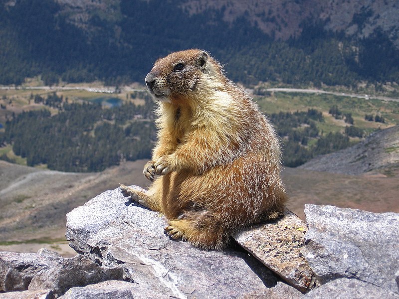
العربية: مرموطٌ أصفر البطن على قمَّة جبل دانا، في مُنتزه يوسيميتي الوطني في كاليفورنيا. الطريق الظاهرة في الخلفيَّة هي طريق معبر تايوگا.
Deutsch: Murmeltier auf dem Mount Dana, Yosemite, Kalifornien, USA.
English: A marmot on top of Mount Dana, Yosemite, CA, USA. The road in the background is Tioga Pass Road.
Español: Marmota (Marmota flaviventris) en la cumbre del Monte Dana, Yosemite, California, Estados Unidos. En el fondo, la carretera a Tioga Pass.
Polski: Świstak żółtobrzuchy (Marmota flaviventris) na szczycie góry Mount DanaParku Narodowym Yosemite, w stanie Kalifornia, w USA. W tle widoczna jest droga Tioga Pass Road.
Čeština: Svišť žlutobřichý (Marmota flaviventris) sedící na vrcholku hory Mount Dana v Yosemitském národním parku, Kalifornie, USA.
Français : Une marmote charnue au sommet du Mont Dana, parc Yosemite, Californie, Etats-Unis. La route en fond est celle du col Tioga
Magyar: Sárgahasú mormota (Marmota flaviventris) a Mount Dana csúcsán. A háttérben a Tioga Pass Road (Yosemite Nemzeti Park, Kalifornia, Amerikai Egyesült Államok)
Italiano: Una marmotta in cima al Monte Dana, Parco nazionale di Yosemite, CA, USA. La strada sullo sfondo è la Tioga Pass Road
한국어: 미국 캘리포니아 주 요세미티의 데이너산 정상에서 촬영한 마멋. 뒷편으로 티오가 패스 로드가 보인다.
Македонски: Мрмот во националниот парк Јосемити, Калифорнија, САД.
Nederlands: Geelbuikmarmot (Marmota flaviventris) op de top van Mount Dana in Yosemite National Park in de Amerikaanse staat Californië
Português: Marmota (Marmota flaviventris) no cume do Monte Dana, Parque Nacional de Yosemite, Califórnia, Estados Unidos.
中文:美国加利福尼亚州约塞米蒂山达纳山上的土拨鼠。图中背景的道路是Tioga通道。
Petsa Taken on 2 Agosto 2007
Gigikanan This file was derived from: Marmot on rocks.jpg
Tagsulat
Other versions Sharpened and curve adjustment of the original:
Camera location37° 53′ 59.6″ N, 119° 13′ 15.9″ W Kartographer map based on OpenStreetMap.View this and other nearby images on: OpenStreetMapinfo
Desktop wallpaper icon
This English Wikipedia featured picture is fairly large and has an aspect ratio of approximately 4:3 or 5:4, making it suitable as a computer wallpaper.

See the gallery of such images, or the gallery of widescreen images.

Assessment

Hulagway of the day
Hulagway of the day
Featured hulagway

Wikimedia CommonsWikipedya

This file was the picture of the day on February 02, 2018.
This is a featured picture on Wikimedia Commons (Featured pictures) and is considered one of the finest images. See its nomination here.

Wikipedya
 This is a featured picture on the Arabic language Wikipedia (صور مختارة) and is considered one of the finest images. See its nomination here.
 This is a featured picture on the English language Wikipedia (Featured pictures) and is considered one of the finest images. See its nomination here.
 This is a featured picture on the Persian language Wikipedia (نگاره‌های برگزیده) and is considered one of the finest images. See its nomination here.

If you have an image of similar quality that can be published under a suitable copyright license, be sure to upload it, tag it, and nominate it.

Pagtugot

Inklein from en.wiki.x.io, the copyright holder of this work, hereby publishes it under the following license:
GNU head Gitugot ang pagkopya, pag-apud-apod o/ug pag-usab ning maong dokumento ubos sa mga termino sa GNU Free Documentation License, Version 1.2 o mas bag-ong bersiyon nga gimantala sa Free Software Foundation; nga walay Invariant Sections, walay Front-Cover Texts, ug walay Back-Cover Texts. Ang kopya sa lisensiya gilakip sa bahin nga giulohang GNU Free Documentation License.
w:en:Creative Commons
atribusyon share parehas
This file is licensed under the Creative Commons Attribution-Share Alike 3.0 Unported license.
Attribution: Inklein
Libre ka:
  • sa pagsabwag – sa pagkopya, pag-apod-apod ug pagsabwag sa hinimo
  • sa pag-remix – sa pag-adap sa binuhat
Ubos sa mosunod nga mga kondisyon:
  • atribusyon – Kinahanglan nimo nga hatagan ang angay nga kredito, maghatag usa ka link sa lisensya, ug ipakita kung adunay mga pagbag-o. Mahimo nimo kini buhaton sa bisan unsang makatarunganon nga paagi, apan dili sa bisan unsang paagi nga nagsugyot nga gi-endorso ka sa licensor o ang imong paggamit.
  • share parehas – Kung imong gi-remix, gibag-o, o gibase sa materyal, kinahanglan nimo nga iapod-apod ang imong mga kontribusyon sa ilawom sa parehas o katugma nga lisensya sama sa orihinal.
This licensing tag was added to this file as part of the GFDL licensing update.

Captions

Add a one-line explanation of what this file represents
Marmot chilling on a rock.

Items portrayed in this file

depicts English

copyrighted English

2 Agosto 2007

37°53'59.600"N, 119°13'15.899"W

exposure time English

0.002 second

f-number English

5.5

focal length English

23.1875 millimetre

media type English

image/jpeg

data size English

2,005,363 byte

height English

1,704 pixel

width English

2,272 pixel

checksum English

cd830c91d13a026ba67f64c9062bb251bb8ae011

Kaagi sa payl

I-klik ang petsa/oras aron makit-an ang hulagway sa payl niadtong panahona.

Petsa/TaknaThumbnailMga dimensyonTiggamitKomento
kasamtangan10:07, 3 Septiyembre 2007Thumbnail sa bersyon sa 10:07, 3 Septiyembre 20072,272 × 1,704 (1.91 MB)Jjron{{Information |Description= A marmot seen on top of Mount Dana, Yosemite, CA, USA. The road in the background is Tioga Pass Road. (Edited version of original: sharpened and curve adjustment by jjron |Source= English Wikipedia |Date=2 Septe

Ang mosunod nga 2 panid misumpay niining payl:

Global nga paggamit sa payl

Kining ubang wiki naggamit ning maong payl:

View more global usage of this file.

Metadata