Payl:Southeast France ESA389292.jpg
Tibuok resolusyon (3,000 × 1,688 pixels, size sa payl: 6.07 MB, MIME type: image/jpeg)
Mubong sugid:
| Deskripsyon |
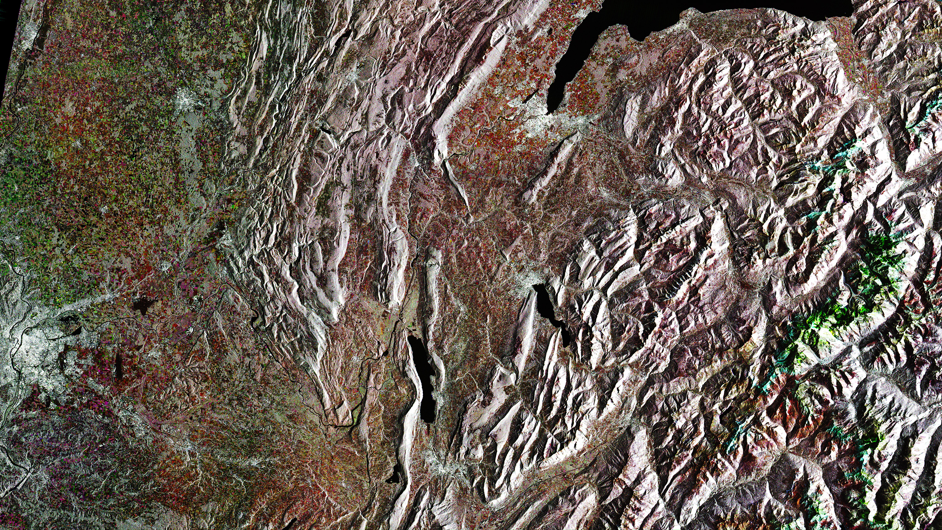
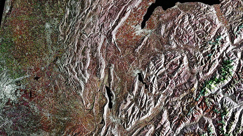
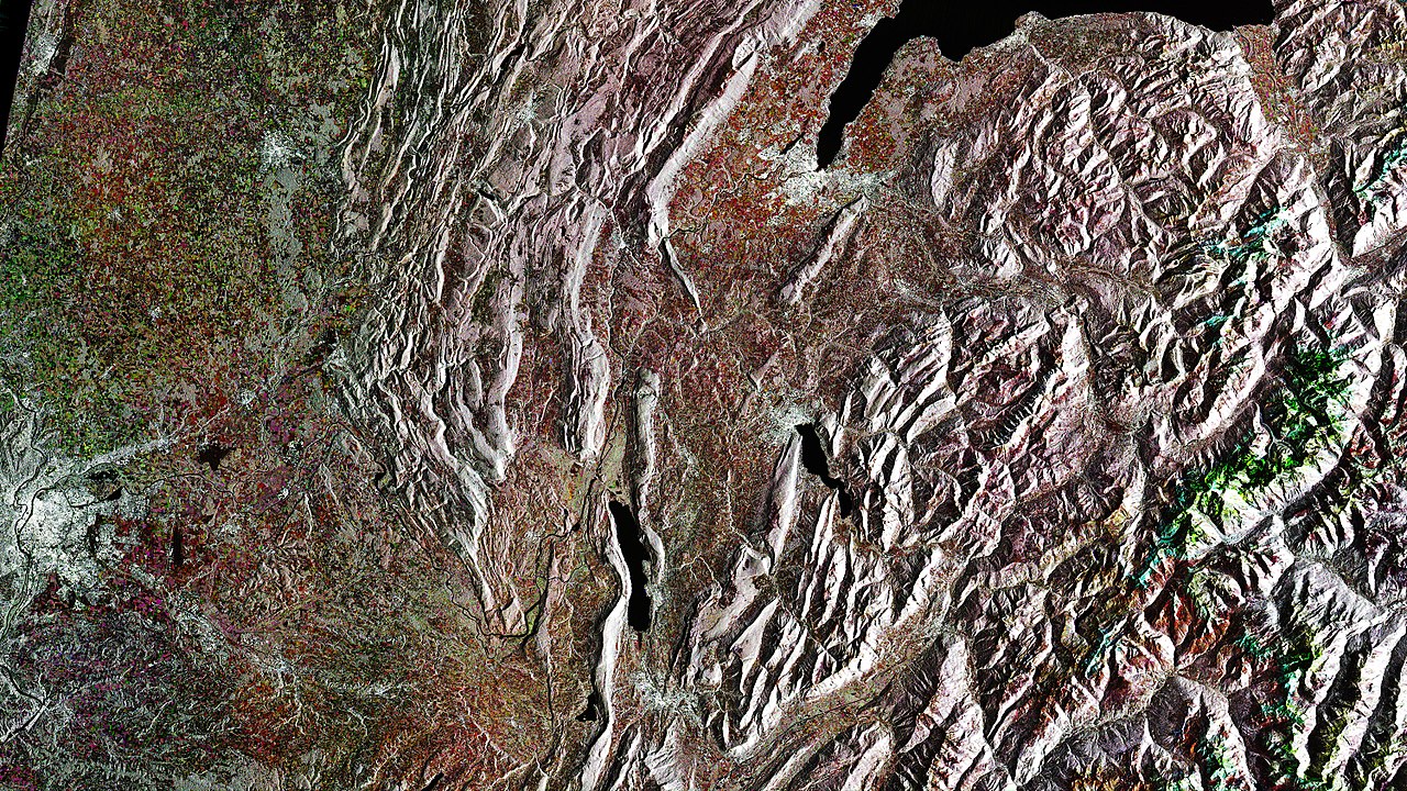
English: This Sentinel-1 radar image captures a stretch of southeast France, from the city of Lyon on the left to the Alps on the right – the northeast part of the Auvergne-Rhone-Alps region. The image is made up of three satellite acquisitions from 13 July, 12 August and 11 September 2017 to highlight any changes on the ground. Grey tones, where there are mountains and towns for example depict no change, but red, green and blue tones indicate where vegetation has changed as summer progressed.
The highest mountain in the Alps, Mont Blanc, which is on the French–Italian border, is featured a little below half way down the right side of the image. To the north of the Alps, part of Lake Geneva can be seen with the Swiss city of Geneva at southwestern end of the lake. Further south and slightly west of the Alps, Lake Annecy and Lake Bourget are visible. To the west of these lakes the land gives way to gentle valleys with Lyon featured on the left side of the image. |
| Petsa | |
| Gigikanan | http://www.esa.int/spaceinimages/Images/2018/01/Southeast_France |
| Tagsulat | European Space Agency |
| Pagtugot (Paggamit pag-usab niini nga file) |
contains modified Copernicus Sentinel data (2017), processed by ESA,CC BY-SA 3.0 IGO |
| Other versions |
|
| Title | Southeast France |
| System | Copernicus |
| Location | Alps |
| Mission | Sentinel-1 |
| Activity | Observing the Earth |

Pagtugot
- Libre ka:
- sa pagsabwag – sa pagkopya, pag-apod-apod ug pagsabwag sa hinimo
- sa pag-remix – sa pag-adap sa binuhat
- Ubos sa mosunod nga mga kondisyon:
- atribusyon – Kinahanglan nimo nga hatagan ang angay nga kredito, maghatag usa ka link sa lisensya, ug ipakita kung adunay mga pagbag-o. Mahimo nimo kini buhaton sa bisan unsang makatarunganon nga paagi, apan dili sa bisan unsang paagi nga nagsugyot nga gi-endorso ka sa licensor o ang imong paggamit.
- share parehas – Kung imong gi-remix, gibag-o, o gibase sa materyal, kinahanglan nimo nga iapod-apod ang imong mga kontribusyon sa ilawom sa parehas o katugma nga lisensya sama sa orihinal.

|
This image contains data from a satellite in the Copernicus Programme, such as Sentinel-1, Sentinel-2 or Sentinel-3. Attribution is required when using this image.
Attribution: Contains modified Copernicus Sentinel data {{{year}}}
The use of Copernicus Sentinel Data is regulated under EU law (Commission Delegated Regulation (EU) No 1159/2013 and Regulation (EU) No 377/2014). Relevant excerpts:
Free access shall be given to GMES dedicated data [...] made available through GMES dissemination platforms [...].
Access to GMES dedicated data [...] shall be given for the purpose of the following use in so far as it is lawful:
GMES dedicated data [...] may be used worldwide without limitations in time.
GMES dedicated data and GMES service information are provided to users without any express or implied warranty, including as regards quality and suitability for any purpose. |
Kaagi sa payl
I-klik ang petsa/oras aron makit-an ang hulagway sa payl niadtong panahona.
| Petsa/Takna | Thumbnail | Mga dimensyon | Tiggamit | Komento | |
|---|---|---|---|---|---|
| kasamtangan | 16:57, 22 Enero 2018 | | 3,000 × 1,688 (6.07 MB) | Fæ | European Space Agency, Id 389292, http://www.esa.int/spaceinimages/Images/2018/01/Southeast_France, User:Fæ/Project_list/ESA |
Mga paggamit sa payl
Ang mosunod nga mga panid misumpay niining payl:
Global nga paggamit sa payl
Kining ubang wiki naggamit ning maong payl:
- Paggamit sa ar.wiki.x.io
- Paggamit sa arz.wiki.x.io
- Paggamit sa ast.wiki.x.io
- Paggamit sa az.wiki.x.io
- Paggamit sa be.wiki.x.io
- Paggamit sa ca.wiki.x.io
- Paggamit sa ce.wiki.x.io
- Paggamit sa de.wikivoyage.org
- Paggamit sa diq.wiki.x.io
- Paggamit sa fr.wikinews.org
- Paggamit sa fr.wikivoyage.org
- Paggamit sa gl.wiki.x.io
- Paggamit sa he.wiki.x.io
- Paggamit sa hy.wiki.x.io
- Paggamit sa ia.wiki.x.io
- Paggamit sa id.wiki.x.io
- Paggamit sa mt.wiki.x.io
- Paggamit sa nn.wiki.x.io
- Paggamit sa no.wiki.x.io
- Paggamit sa oc.wiki.x.io
- Paggamit sa pl.wiki.x.io
- Paggamit sa sr.wiki.x.io
- Paggamit sa tt.wiki.x.io
- Paggamit sa uk.wiki.x.io
- Paggamit sa vec.wiki.x.io
- Paggamit sa vi.wiki.x.io
- Paggamit sa www.wikidata.org