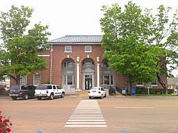
Tippah County
Kondado ang Tippah County (Prinanses: Comté de Tippah, Kinatsila: Condado de Tippah) sa Tinipong Bansa.[1] Nahimutang ni sa estado sa Mississippi, sa habagatan-sidlakang bahin sa nasod, 1,200 km sa kasadpan sa Washington, D.C. Adunay 22,232 ka molupyo.[1] Naglangkob kin og 1,191 ka kilometro kwadrado. Tippah County mopakigbahin sa usa ka utlanan sa Hardeman County, Alcorn County, Prentiss County, Union County, ug Benton County ang ulohan sa nasod.
| Tippah County (Comté de Tippah) | |
| Condado de Tippah | |
| Kondado | |
| Nasod | |
|---|---|
| Estado | Mississippi |
| Gitas-on | 165 m (541 ft) |
| Tiganos | 34°46′06″N 88°54′32″W / 34.7684°N 88.9089°W |
| Capital | Ripley |
| Area | 1,191.00 km2 (460 sq mi) |
| Population | 22,232 (2013-03-07) [1] |
| Density | 19 / km2 (49 / sq mi) |
| Timezone | CST (UTC-6) |
| - summer (DST) | CDT (UTC-5) |
| GeoNames | 4448467 |
Ang yuta sa Tippah County kay patag.[saysay 1]
Tippah County may sa mosunod nga mga subdibisyon:
Mga lungsod sa Tippah County:
Sa mosunod nga mga natural nga mga bahin makita sa Tippah County:
- Mga suba:
- Bartlett Branch (suba)
- Bell Creek (suba)
- Big Branch (suba)
- Big Creek (suba)
- Bill Creek (suba)
- Bluff Creek (suba)
- Bowling Branch (suba)
- Briar Branch (suba)
- Briar Branch (suba)
- Brougher Creek (suba)
- Brush Branch (suba)
- Brush Creek (suba)
- Bumpass Creek (suba)
- Burton Branch (suba)
- Camp Creek (suba)
- Cane Branch (suba)
- Caney Branch (suba)
- Clear Creek (suba)
- Colson Branch (suba)
- Cook Creek (suba)
- Coomb Branch (suba)
- Copeland Branch (suba)
- Cox Branch (suba)
- Crum Creek (suba)
- Dean Creek (suba)
- Dodd Creek (suba)
- Drewery Creek (suba)
- Dry Creek (suba)
- Embry Creek (suba)
- Foley Creek (suba)
- Foshea Branch (suba)
- Fourmile Branch (suba)
- Freeman Branch (suba)
- Fryar Branch (suba)
- Gossett Branch (suba)
- Gray Creek (suba)
- Green Bay Branch (suba)
- Guyton Creek (suba)
- Hall Creek (suba)
- Hamilton Branch (suba)
- Harden Branch (suba)
- Hersey Branch (suba)
- Hobson Branch (suba)
- Holliday Creek (suba)
- Holly Branch (suba)
- Hurricane Creek (suba)
- Irington Branch (suba)
- Ishitubba Creek (suba)
- Jennings Branch (suba)
- Jones Creek (suba)
- Jonesboro Creek (suba)
- Lewallen Branch (suba)
- Linebarger Branch (suba)
- Little Creek (suba)
- Little Hatchie River (suba)
- May Creek (suba)
- McAllister Creek (suba)
- Medlock Branch (suba)
- Middle Creek (suba)
- Mitchell Branch (suba)
- Mix Branch (suba)
- Murley Branch (suba)
- Neely Branch (suba)
- North Branch Hurricane Creek (suba)
- North Prong Muddy Creek (suba)
- North Tippah Creek (suba)
- Overton Creek (suba)
- Owl Creek (suba)
- Panther Creek (suba)
- Phyfer Creek (suba)
- Pink Branch (suba)
- Pool Branch (suba)
- Pressley Branch (suba)
- Ray Branch (suba)
- Ray Creek (suba)
- Robbin Creek (suba)
- Rushing Branch (suba)
- Rutherford Branch (suba)
- Sand Branch (suba)
- Sand Gulley (suba)
- Scruggs Branch (suba)
- Shackelford Branch (suba)
- Short Creek (suba)
- Simmons Branch (suba)
- Smith Branch (suba)
- Smith Branch (suba)
- Smith Creek (suba)
- Sorghum Creek (suba)
- South Branch Hurricane Creek (suba)
- South Tippah Creek (suba)
- Spicewood Creek (suba)
- Stave Mill Branch (suba)
- Street Branch (suba)
- Stubb Branch (suba)
- Thomas Creek (suba)
- Thompson Branch (suba)
- Town Creek (suba)
- Turkey Branch (suba)
- Turkey Creek (suba)
- Walker Creek (suba)
- Walnut Creek (suba)
- Watkins Branch (suba)
- West Branch Jasper Creek (suba)
- West Prong Muddy Creek (suba)
- White Oak Creek (suba)
- Wingo Branch (suba)
- Mga kanal:
- Mga lanaw:
- Mga walog:
- Kabukiran:
Ang klima umogon ug subtropikal.[3] Ang kasarangang giiniton 15 °C. Ang kinainitan nga bulan Hunyo, sa 23 °C, ug ang kinabugnawan Enero, sa 2 °C.[4] Ang kasarangang pag-ulan 1,669 milimetro matag tuig. Ang kinabasaan nga bulan Disyembre, sa 196 milimetro nga ulan, ug ang kinaugahan Nobiyembre, sa 103 milimetro.[5]
| ||||||||||||||||||||||||||||||||||||||||||||||||||||||||||||||||||||||||||||||||||||||||||||||||||||||||||||||||||||||||||||
Saysay
usbaAng mga gi basihan niini
usba- ↑ 1.0 1.1 1.2 Tippah County sa Geonames.org (cc-by); post updated 2013-03-07; database download sa 2017-02-28
- ↑ "Viewfinder Panoramas Digital elevation Model". 2015-06-21.
- ↑ Peel, M C; Finlayson, B L. "Updated world map of the Köppen-Geiger climate classification". Hydrology and Earth System Sciences. 11: 1633–1644. doi:10.5194/hess-11-1633-2007. Retrieved 30 Enero 2016.
{{cite journal}}: CS1 maint: unflagged free DOI (link) - ↑ 4.0 4.1 "NASA Earth Observations Data Set Index". NASA. Retrieved 30 Enero 2016.
- ↑ "NASA Earth Observations: Rainfall (1 month - TRMM)". NASA/Tropical Rainfall Monitoring Mission. Retrieved 30 Enero 2016.
Gikan sa gawas nga tinubdan
usba| Aduna'y mga payl ang Wikimedia Commons nga may kalabotan sa artikulong: Tippah County. |


