Tobago (rehiyon)
- Alang sa ubang mga dapit sa mao gihapon nga ngalan, tan-awa ang Tobago.
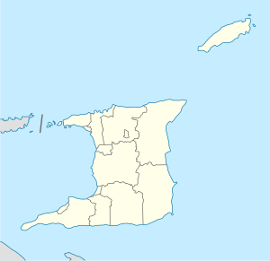
Rehiyon ang Tobago sa Trinidad ug Tobago.[1] Nahimutang ni sa amihanan-sidlakang bahin sa nasod, 110 km sa amihanan-sidlakan sa Port-of-Spain ang ulohan sa nasod. Adunay 62,219 ka molupyo.[1] Ang Tobago nahimutang sa pulo sa Tobago.[saysay 1]
| Tobago | |
| Rehiyon | |
| Nasod | Plantilya:Country data Trinidad ug Tobago |
|---|---|
| Gitas-on | 368 m (1,207 ft) |
| Tiganos | 11°15′00″N 60°40′00″W / 11.25°N 60.66667°W |
| Population | 62,219 (2016-05-11) [1] |
| Timezone | AST (UTC-4) |
| GeoNames | 3573606 |
Tobago may sa mosunod nga mga subdibisyon:
Mga lungsod sa Tobago:
Sa mosunod nga mga natural nga mga bahin makita sa Tobago:
- Mga luuk:
- Anse Brisant (luuk)
- Arnos Vale Bay (luuk)
- Back Bay (luuk)
- Barbados Bay (luuk)
- Bateau Bay (luuk)
- Bishops Bay (luuk)
- Bloody Bay (luuk)
- Buccoo Bay (luuk)
- Cambleton Bay (luuk)
- Canoe Bay (luuk)
- Carapuse Bay (luuk)
- Castara Bay (luuk)
- Celery Bay (luuk)
- Culloden Bay (luuk)
- Delaford Bay (luuk)
- Englishman's Bay (luuk)
- Flamengo Bay (luuk)
- Fourmi Bay (luuk)
- Fromager Bay (luuk)
- Goldsborough Bay (luuk)
- Gordon Bay (luuk)
- Gouleme Bay (luuk)
- Great Courland Bay (luuk)
- Hermitage Bay (luuk)
- Hillsborough Bay (luuk)
- Iguana Bay (luuk)
- King Peter's Bay (luuk)
- King's Bay (luuk)
- La Guira (luuk)
- Little Bay (luuk)
- Little Englishmans Bay (luuk)
- Little Rockly Bay (luuk)
- Lucy Vale Bay (luuk)
- Man of War Bay (luuk)
- Mangrove Bay (luuk)
- Milford Bay (luuk)
- Minister Bay (luuk)
- Mount Irvine Bay (luuk)
- Parlatuvier Bay (luuk)
- Petit Trou (luuk)
- Pinfold Bay (luuk)
- Pirates Bay (luuk)
- Prince's Bay (luuk)
- Queen's Bay (luuk)
- Richmond Bay (luuk)
- Rockly Bay (luuk)
- Sandy Point Bay (luuk)
- Stone Haven Bay (luuk)
- Store Bay (luuk)
- Tyrrel's Bay (luuk)
- Washerwomen's Bay (luuk)
- Mga suba:
- Argyle River (suba)
- Bacolet River (suba)
- Belle River (suba)
- Bloody Bay River (suba)
- Castara Down River (suba)
- Castara River (suba)
- Centre River (suba)
- Clinton River (suba)
- Coffee River (suba)
- Cook's River (suba)
- Courland River (suba)
- Cow Foot River (suba)
- Cranmore River (suba)
- Darrell Spring River (suba)
- Dead Bay River (suba)
- Doctors River (suba)
- Englishman's Bay River (suba)
- Erasmus River (suba)
- Frenchmans River (suba)
- Goldsborough River (suba)
- Hillsborough East River (suba)
- Hillsborough West River (suba)
- Inverawe River (suba)
- Kings Bay River (suba)
- Lambeau River (suba)
- Mc Rae River (suba)
- Morne d'Or River (suba)
- Parlatuvier East River (suba)
- Parlatuvier West River (suba)
- Pembroke River (suba)
- Providence River (suba)
- Queens River (suba)
- Richmond River (suba)
- Roxborough River (suba)
- Sandy River (suba)
- Steele River (suba)
- Stetin River (suba)
- Wild Cow River (suba)
- Wild Dog River (suba)
- Salog sa dagat:
- Mga lanaw:
- Kapuloan:
- Nga bato nga pormasyon:
- Barrel of Beef Rock (bato)
- Black Rock (bato)
- Black Rock (bato)
- Black Rock (bato)
- Cardinal Rock (bato)
- London Bridge Rock (bato)
- Long Rock (bato)
- Middle Rock (bato)
- Minster Rock (bato)
- North East Rock (bato)
- Pointed Rock (bato)
- Red Rocks (mga bato)
- Roxborough Rock (bato)
- Sluice Rock (bato)
- South Rock (bato)
- White Rock (bato)
- Wolf Rock (bato)
- Mga bungtod:
- Mga lawis:
- Bacolet Point (punta)
- Booby Point (punta)
- Cape Gracias-a-Dios (punta)
- Columbus Point (punta)
- Corvo Point (punta)
- Courland Point (punta)
- Crown Point (punta)
- Granby Point (punta)
- Hawk's Bill (punta)
- Lodge Point (punta)
- Lowlands Point (punta)
- Minster Point (punta)
- North Point (punta)
- Pedro Point (punta)
- Pigeon Point (punta)
- Red Point (punta)
- Rocky Point (punta)
- Sandy Point (punta)
- Sheerbirds Point (punta)
- Kabukiran:
- Kagaangan:
Saysay
usbaAng mga gi basihan niini
usba- ↑ 1.0 1.1 1.2 Tobago sa Geonames.org (cc-by); post updated 2016-05-11; database download sa 2017-01-30
- ↑ "Viewfinder Panoramas Digital elevation Model". 2015-06-21.
